It's done! And it's just the beginning.
After 5 years, the first continent on Rynaga has been surveyed and captured in this 24x36 print.
Creating the Map
Writing, planning, drawing, more planning - this map has been a study in calculated refinement. It's great to be done, but knowing how we've set ourselves up for telling a meaningful story over the coming years feels just as good.
During it's creation, the Explorer's Map weathered two failed computer systems, survived its own journey on a misplaced USB drive and pushed my new computer to the limits of its processing power.
I can tell you this though: no single part of this project has been more meaningful to accomplish for me. This finished map is now a powerful symbol of our commitment to the Rynaga project and the stories which are yet to come.
Features of the Map
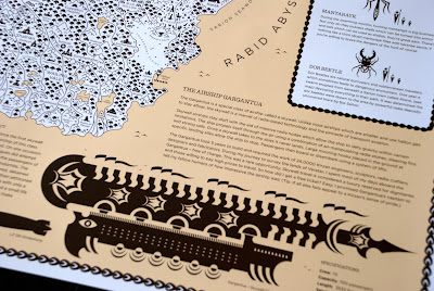
The first thing you will notice is detail, tons of detail. The map references 393 different locales and incorporates hundreds of individually placed icons which represent landmarks such as forests, deserts and ruined cities.
There's more. Beyond exploring the locations and iconography, traveler’s will learn more about Rynaga’s powerful sources of energy, amazing forms of wildlife and legendary modes of travel.
Throughout the map are hidden details, such as references to Iconica characters and cards, poetry, cryptic messages and even an all encompassing riddle. The bottom line: this map is a journey in of itself!
Start Exploring
In order for Rynaga to be real to our supporters, it must be real to us. This starts by creating a landscape worthy of great quests, like those of Lewis and Clark, Leif Ericson and Ernest Shackleton.
We hope this map will inspire hours of travel-by-imagination! Thanks for your support.
-Safe travels!
Subscribe to:
Post Comments (Atom)


No comments:
Post a Comment